
HSFF has assembled a collection of maps of Santa Fe and nearby areas with map dates beginning in 1766 and including a few maps from recent times. These maps are posted as an aid for people who are simply curious or are researching the architectural and cultural history of Santa Fe.
Use of these maps is for research purpose only. If any materials within the collection have copyrights that are retained by any individual, agency or organization, it is the researcher’s responsibility to respect these rights.
The collection continues to grow as other maps are acquired. A list of the collection—arranged by date—follows. To see any map in greater detail click on the map itself and a pdf version should appear. Near the bottom of the screen is a zoom tool.
COPYRIGHT NOTICE: You may reproduce these images in accordance with the “fair use” provisions of the United States Copyright Act. The fair use exceptions are noncommercial criticism, comment, news reporting, teaching, scholarship, education and research. If you wish to reproduce those images in whole or in part for commercial purposes, it is your obligation to secure those rights. Historic Santa Fe Foundation (HSFF) provides these maps solely for research purposes. HSFF does not grant or otherwise authorize you to reproduce images of the maps created after 1909 without the express written consent of the copyright owner.
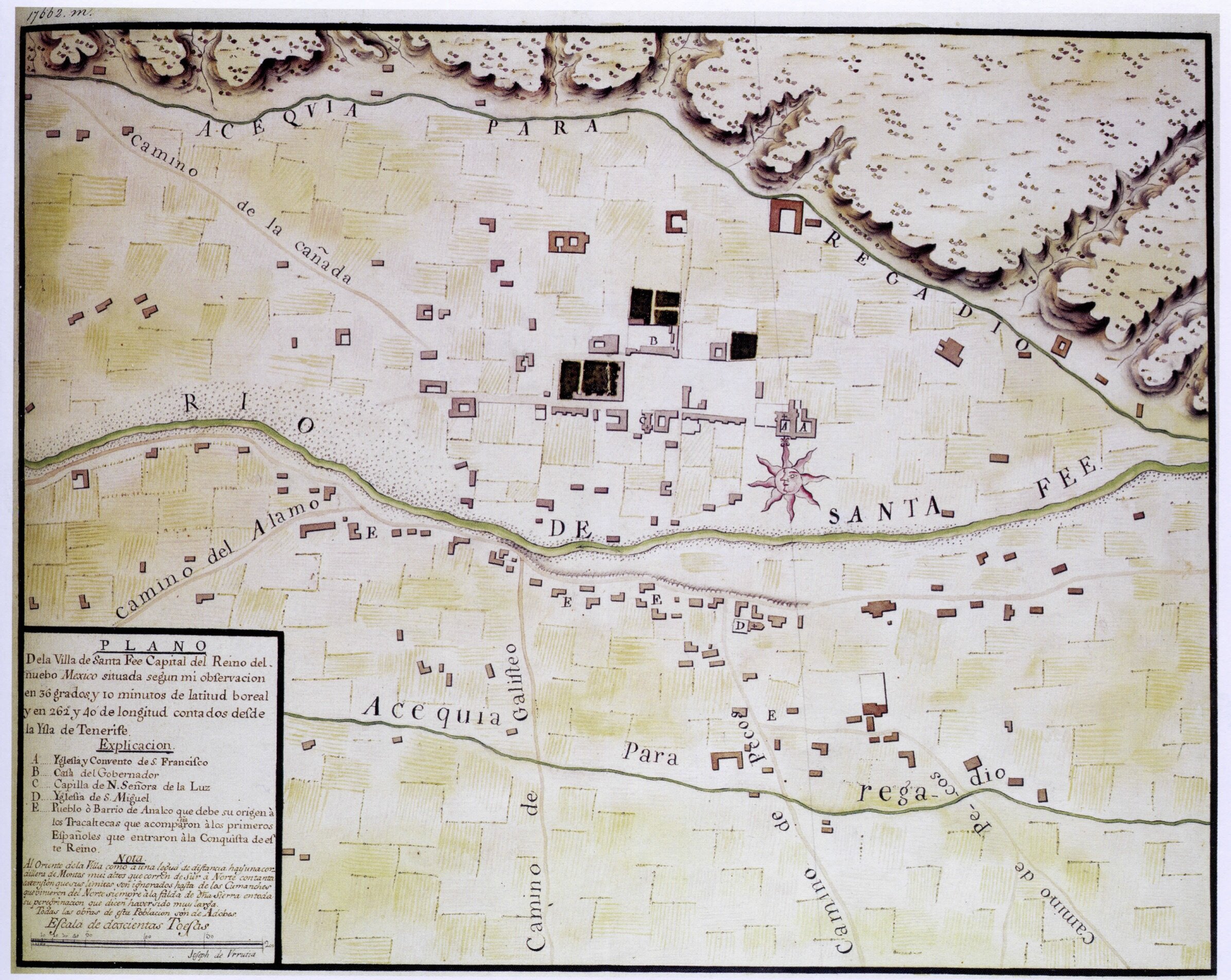
1766 Plano de la Villa de Santa Fee, Nuebo Mexico. Earliest known map of Santa Fe. Drawn by Joseph de Urrutia, a draughtsman who accompanied the Marqués de Rubí on an inspection tour of the 21 presidios in northern New Spain during the summer of 1766. The colored map accurately shows the major topographical features in Santa Fe at that time, including the locations and names of the major roads in and out of town, the major acequias, the plaza and public buildings, the three churches and scattered residences along the Rio de Santa Fe. A written Explicacion, or key lists and locates the primary buildings as “A Yglesia y Convento de S, Francisco, B Casa del Gobernador, C Capilla de N. Señora de la Luz, D Yglesia de S. Miguel.” It also lists and locates the “Pueblo o Barrio de Analco que debe su origen à los Tracaltecas que acompñaron à los primeros Españoles que entraron àla Conquista de este Reina.” (District of Analco which owes its origin to the Tracaltecas who accompanied the first Spanish who entered at the Conquest of this kingdom). There is a further description of the mountains to the east of Santa Fe running from south to north to where the Comanches live. This is followed by a note that all of the buildings are of adobe. The land devoted to agriculture is indicated by cross hatching and color. It is remarkable that agriculture occupies a vast amount of land in relation to that devoted to the built structures.

1771 Mapa de toda la frontera de los dominios del rey en la America septentrional. Nicolás de la Flora, captain in the Corps of Royal Engineers, served with the Marqués de Rubí on an inspection tour of the 21 presidios in northern New Spain during 1766-67. Laflora and Joseph de Urrutia are listed as co-authors of the maps produced on this expedition, although it is likely that Urrutia was the actual draftsman. The upper portion of the Mapa centers on the upper Rio del Norte indicating settlements from San Pascual in the south to Abiquiu in the north.

1791 Plan de el Presidio de Sta. Fé de el Nuevo Mexico by Juan de Pagazaurtundúa. With the suppression of the Pueblo Revolt, the Spanish government established military forts or Presidios in El Paso and Santa Fe. By 1791 the Presidio in El Paso had been abandoned, but Santa Fe’s had received substantial improvements and enlargements. This depicts the Presidio as improved. From Marc Simmons, published in his Spanish Government in New Mexico along with Simmons’ translations
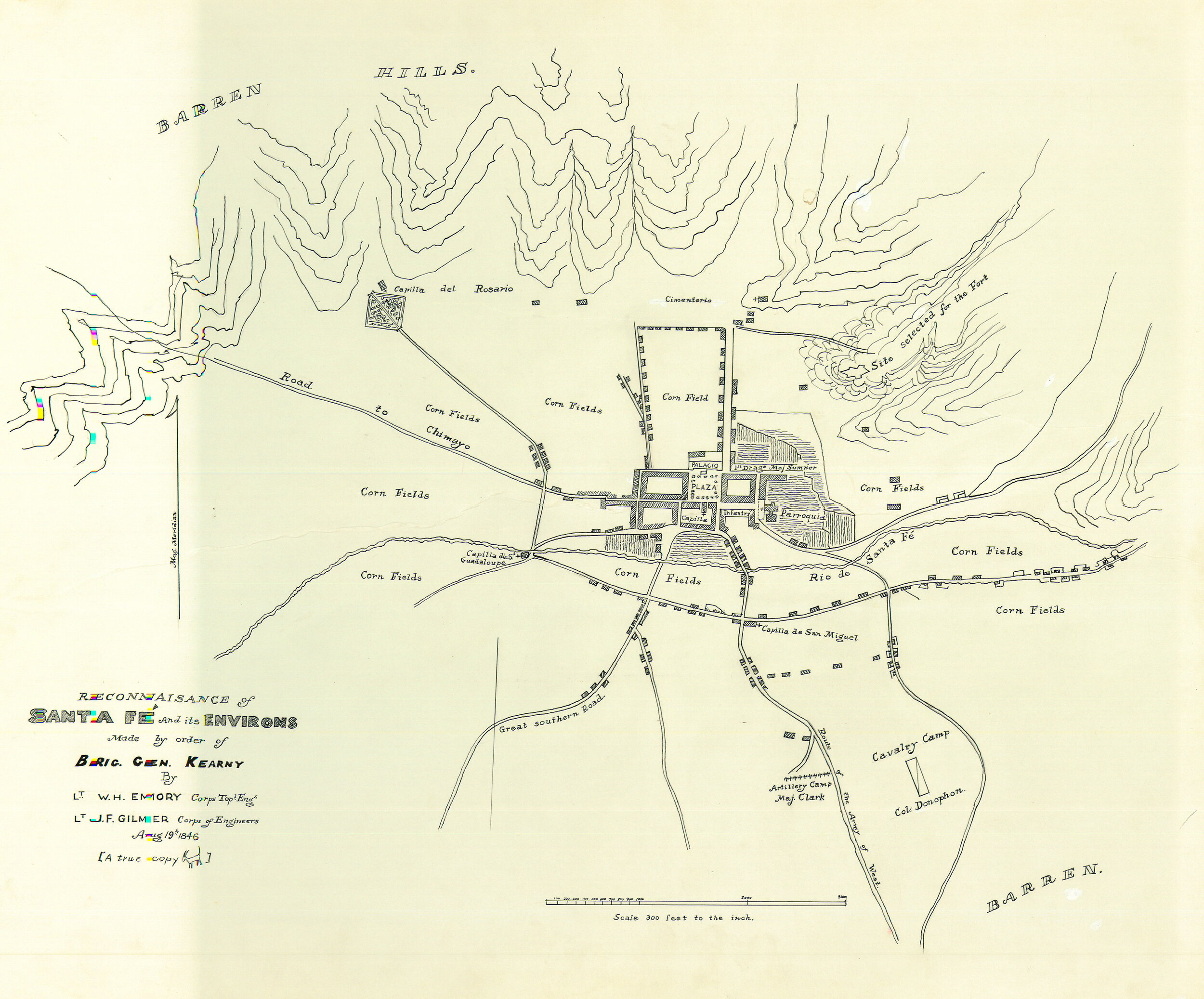
1846, August 19 Reconnaissance of Santa Fe by Gilmer. Surveyed and drawn by Lts. Emory and Gilmer. Evidently a first draft, preliminary to the 1846 Plan. Undertaken immediately upon Kearney’s entry into Santa Fe on August 18th. The major roads in and out of Santa Fe and the major buildings are named and located. Separate locations are indicated for the cavalry, the artillery, the infantry and the dragoons. A “Site selected for the Fort” is indicated atop an escarpment to the northeast of the plaza where the construction of Fort Marcy was soon begun.
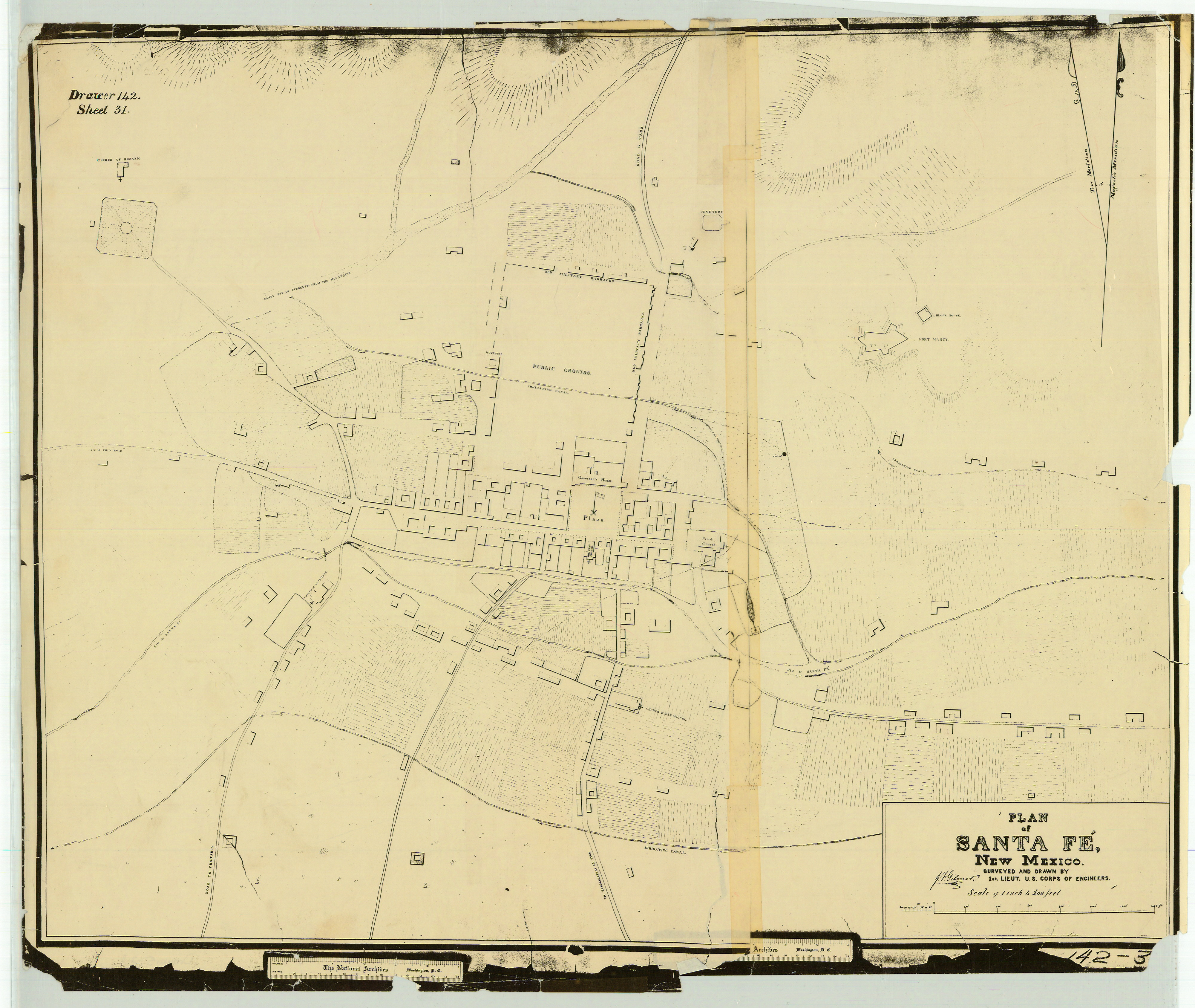
1846-7 Plan of Santa Fe by Gilmer. Map of Santa Fe surveyed by Lt. Gilmer, Corps of Engineers, who accompanied Kearney to Santa Fe. More complete than the August 19, 1846 Reconaissance, The Plan more accurately shows the built environment and in more detail, but there is considerably less naming of buildings and topographical features. The main walls of Fort Marcy appear.

1877 Plat of the City of Santa Fe Grant. Survey of the city’s boundaries, with limits at one league from the Plaza, surveyed by Griffin and McMullen, deputy U.S. Surveyors, September, 1877. The map illustrates the City’s decades-long attempt to procure title to the land it had occupied since founding. The City’s effort to have the grant certified by the U.S. government was initiated in 1874 but only confirmed by an act of Congress in 1900. ThIS copy was made in 1901 due to the “dilapidated condition” of the original.

1880 Plat 864351 (Santiago Ramirez Grant). Township No. 16 North, Range 10 east, showing the area from Arroyo Hondo to Cañoncito east of Santa Fe. Certified by Henry M. Atkinson the Surveyor General, July 29, 1880. Atkinson served as Surveyor General for 8 years until the Court of Private Land Claims was established in 1891. During his tenure he was notorious for rulings on matters in which he was an “interested party.” The Santiago Ramirez Grant is seen on this map in Section 2.

1882 Map of Santa Fe by P.O. Gaynor. Shows many street names, subdivisions, prominent buildings and names of property owners. Useful for comparison with Stoner’s Bird’s Eye View of 1882.

1882 Stoner Bird's Eye View of the City of Santa Fé New Mexico. Panoramic maps, also called Bird’s Eye View maps, became very popular in the United States during the late 19th and early 20th Centuries. They allowed towns, especially in the developing west, to demonstrate how advanced and progressive they were. The J.J. Stoner company has some 93 different maps in the Library of Congress collection. Not drawn to any particular scale, but otherwise moderately accurate, they featured realistic impressions of street patterns, notable buildings and major landscape features, as does the Stoner Bird’s Eye View of Santa Fe, produced shortly after the arrival of the Atchison, Topeka and Santa Fe railroad in 1880. Library of Congress copy.

1883 Sanborn map of Santa Fe. The 1883 Edition Consists of 3 sheets. The earliest map by the Sanborn Map Company documenting Santa Fe. First in a series of Sanborn fire insurance maps of the city published intermittently until 1948 showing streets, buildings, building materials, business types and water utility lines for suppression purposes. The HSFF collection contains every version produced by Sanborn for Santa Fe except for the 1948 revision of the 1930 version. HSFF copies are black-and-white, without color. (The City of Santa Fe Historic Preservation Division owns a colored copy that was published January 1930 with a correction record of 1964, 66, 68, 69, 70, and 71.The corrections are in the form of colored paper cutouts that have been pasted over existing imagery.)

1883 Topographical Map of Santa Fe County, New Mexico. “Compiled from Wheelers U.S. Geographical Maps and Original Survey Plats in Surveyor General’s Office Santa Fe by E.KingmanJr”. Shows outlines of “Confirmed Grants, Unconfirmed Grants Approved, Rail Roads, Proposed Roads”.

1885-6 Hartman Map ofthe City of Santa Fe, New Mexico. Shows streets and street names, properties and some owners.

1886 Sanborn Maps of Santa Fe. The 1886 edition consists of 4 sheets.

1889 Santa Fe, U.S. Geological Survey. 1963 reprint of the 1889 map. A colored contour map of Santa Fe and the surrounding area. Scale = 1:125,000. Contour interval of 100 feet.

1890 Sanborn Maps of Santa Fe. The 1890 edition consists of 6 sheets.

1891 Sketch Map of Grants within the Santa Fe Grant by Wm. White. Preliminary to plans to expand the city limits.

1892 Map of Santa Fe New Mexico by P.O. Gaynor, C. E. (partial) Shows streets, street names, subdivisions, lot lines and owners of major lots.

1892-4 Map Showing Owners of Lands Within Santa Fe Land Grant Outside of Santa FE City Limits. Shows the boundaries and the names of grantees within the Santa Fe Grant Also shows the location of the major roads in and out of Santa Fe and the location of the AT&SF railroad tracks and of the Santa Fe branch of the Denver and Rio Grande railroad.
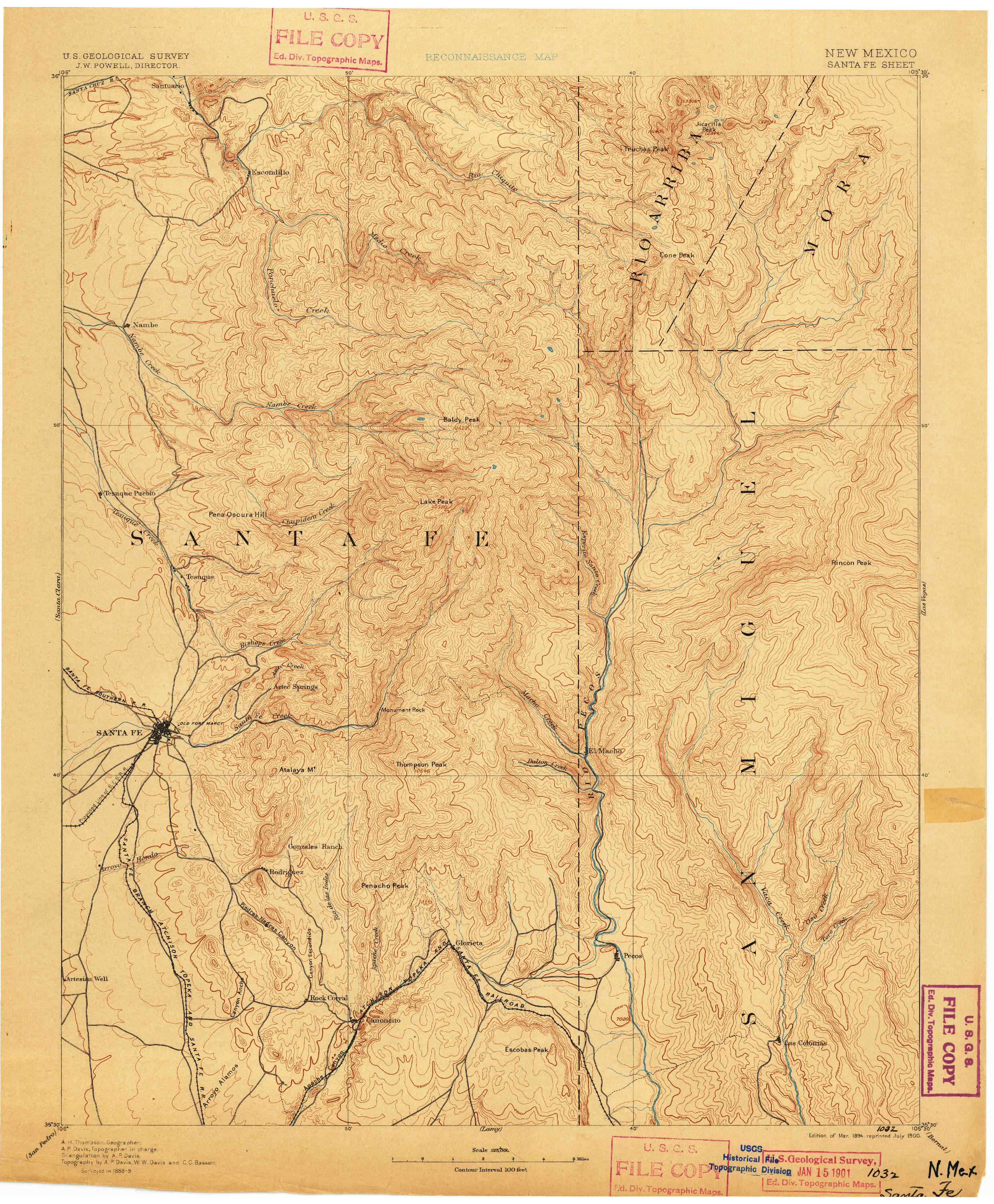
1894 Santa Fe USGS. 1901 reprint of a contour map of Santa Fe created by the U.S. Geological Survey in 1894. The map’s boundaries are from 350 30’ N to 360 0” and from 1050 30” E 1060 0”. Contour interval=100 feet.

1898 Sanborn Maps of Santa Fe. The 1898 edition consists of 6 sheets.

1902 Sanborn Maps of Santa Fe. The 1902 edition consists of 10 sheets.

1904 Official Topographical Map of Santa Fe, New Mexico by John L. Zimmerman, County Surveyor. The map shows all of Santa Fe County. Shows mining districts, railroads and some grants in the county.

1908 Sanborn Maps of Santa Fe. The 1908 edition consists of 11 sheets.

1912 Kings Official Map of the City of Santa Fe New Mexico. Shows Blocks, lots and lot owners, emphasizing new additions to the south of the Capitol.

1912 Map of the Marquez and Padilla Grant Santa Fe County New Mexico as Surveyed by Thomas A. Hayden, C.E.

1913 Sanborn Maps of Santa Fe. The 1913 edition consists of 12 sheets

1914 (circa) Map of Lots and Right-of-Way above Two Mile Reservoir. Showing the "Power Ditch" and the right of way for this ditch for use by the Santa Fe Water and Light Company. The “Power Ditch” was used to supplement water from the 2-Mile Reservoir as the power source for the Hydro Electric plant, built by the Santa Fe Water and Light Company in 1891.

1914-17 Hydrographic Survey of the Santa Fe Creek. the map is downloadable in 4 parts (Click on the part you want to view). Sheets 1-11. sheets 12-22. Sheets 23-33. Sheets 34-45. State Engineer's maps of the Santa Fe Creek, excluding the section within the City Limits. The Survey consists of 45 sheets with a small scale sheet showing the entire watershed from Santa Fe Lake to the confluence of the “Santa Fe Creek” and the Rio Grande. The Survey was administered by “James a French”, New Mexico’s first State Engineer. As the Creek approaches Santa Fe, the scale expands to show highly detailed information of land ownership and property boundaries, acequia locations, planted areas and crop identification, elevation contours and topographical data, outlines of built structures and survey points. The area within the City Limits is excluded. The final sheet ends the Survey at what is approximately the place where State Highway 599 crosses the riverbed at the present.

1921 Sanborn Maps of Santa Fe. The 1921 edition consist of 12 sheets.

1924 Map of the Real Estate Holdings of the Santa Fe Water & Light Company, Santa Fe, New Mexico in the Vicinity of the Reservoir. Land adjacent to the Two Mile Reservoir. Surveyed by Glen Haste, Licensed Surveyor.

1929 De Vargas Development Company, Santa Fe, New Mexico. General Plan for Subdivision. By A.F. Brinkerhoff, Landscape Architect. A subdivision of 72 lots bordered on the north and east by present Camino del Monte Sol, the south by present Old Santa Fe Trail, and the west by property owned by Amelia White (partially bequeathed to the School of Advanced Research).

1930 Sanborn Maps of Santa Fe. The 1930 edition consists of 22 sheets.

1942 Sanborn Maps of Santa Fe. The 1942 edition consist of 22 sheets.

1960 Map from "Property Planning Report, New Mexico School for the Deaf". A sketch map by Kenneth Clark, Architect.

1962 Santa Fe, U.S. Geological Survey. A “limited revision” of the 1954 map. Extends from Latitude 350 30’N to 360N and from Longitude 1040E to 1060E.
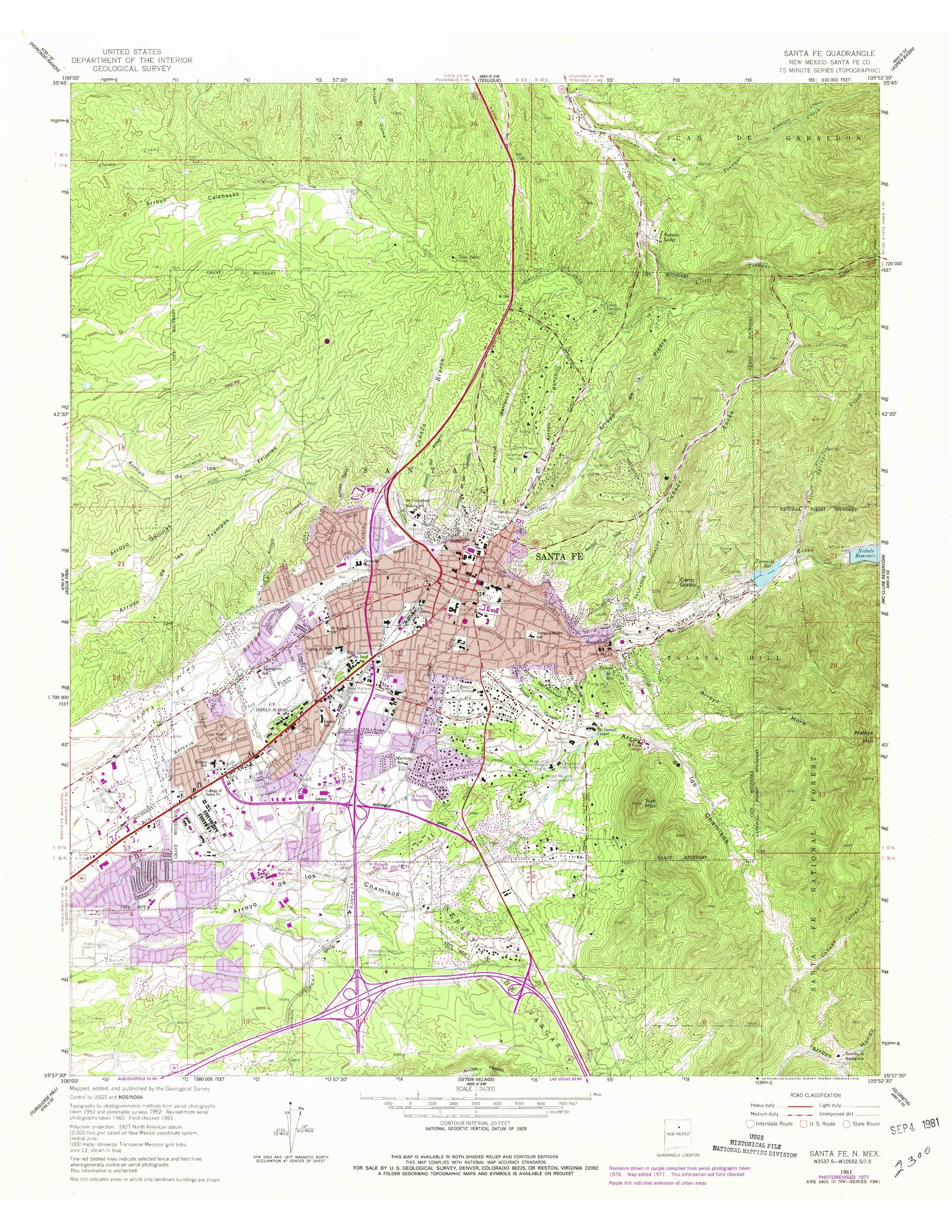
1977 Santa Fe, U.S. Geological Survey. A “photo revised” version of the 1961 USGS map of Santa Fe, updated as of 1977 and identifying current elements of the build environment.

2000 Plan of St. Francis Basilica Cathedral. Showing areas of alterations to a baptism font and altar area. By Vic Johnson, Architect. Courtesy of Vic Johnson

2012 Kings Map of 1912 with Major Acequias Overlaid by Edward Gonzales. Gonzales, a retired consultant for the NM State Engineer, produced this map to memorialize the centennial of NM statehood. It employ's field investigating to identify the locations of Santa Fe's major acequias as they existed in 1912. Courtesy Edward Gonzales.

2016 Sanborn Legend, Key and Abbreviations. From website of Environmental Data Resource, Inc. Consisting of 4 sheets.